Tuesday, February 17, 2004 Last modifiedSunday, April 13, 2003 11:58 PM PDT
Allen Throop/For Mid-Valley Sport
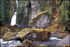
The Eagle Creek Trail carves a rugged path from the Columbia River high
into the Cascades of northern Oregon, following the picturesque Eagle
Creek. At times, only an iron guardrail protects hikers from a 100-foot
plunge into the creek.
Gorgeous!
Eagle Creek special even by Gorge standards
By Allen Throop For Mid-Valley Sports
EAGLE
CREEK — "Looks like it will burn off soon," Bob stated with conviction
as the mist of the Columbia River Gorge swallowed our car.
We were headed for a trailhead, so he tried hard to ignore the rain.
Despite, or perhaps because of, the rain our two days of hiking in the gorge were idyllic.
Three
of the four of us had never hiked the Eagle Creek Trail. Our trail
expert was convinced that it was the quintessential Oregon hike.
The
guidebook seems to agree with her opinion but pointed out that
trailhead parking is difficult to find after 8:30 a.m., and isolation
from other hikers is impossible.
But by choosing a wet weekday
in early spring, we were rewarded with an empty parking lot and a
collage of flowers, rocks, trees, moss, lichen and even waterfalls that
fair-weather crowds never see.
In dry weather or wet, the Eagle
Creek Trail quickly sorts out the serious hiker from the timid. The
expression "they don't build them like they used to" certainly applies
to this trail.
The people who designed and built the Columbia River Scenic Highway in 1915 also had the vision to build the Eagle Creek Trail.
Once
they decided that a trail was needed to entice the highway tourists to
stay, simple obstacles like vertical cliffs were not going to stop the
road or trail builders. They had plenty of experience blasting ledges
for the highway, so blasting a four-foot wide trail into the side of a
cliff was an easy task.
No one asked for an environmental impact statement back then — they just built the trail.
The
original crews approached the project with a good plan and with plenty
of dynamite. Their handiwork has stood the test of time.
While the footing is rock-solid, the surface is rough. The basalt overhead alternately drips or cascades water onto the trail.
A cable handrail is firmly attached to the inside wall, leaving hikers exposed to a drop of over 100 feet into the creek.
Such
exposure must weed out some hikers, but still, in summer the trail is
busy. On our chosen wet day in late March, we encountered few others.
Even
without counting the water falling from the cliffs directly onto the
trail, we saw at least 10 times the number of waterfalls that exist in
the summer. Whether they're high, broad, misty or complex, the gorge
has them in abundance in spring.
An incredible variety of green colors dominated the views.
The
moisture and soft light brought out colors in the moss, the lichen and
the ferns that moved them to center stage from their normal role as bit
players.
Dark green, yellow-green, blue-green, gray-green,
lemon-green — each species claimed a distinctive color. Spring flowers,
including trillium, glacier lilies and bleeding hearts, were blooming
but blended into the green rather than standing apart, as they will by
early summer.
The big-leafed maples demanded our attention for spring attire and the new buds.
Green
moss, lichen and ferns covered the branches. Once the leaves return,
this understory of life will be masked from view again but during our
visit they were often dramatically silhouetted against the gray sky or
the black basalt cliffs.
The tip of each branch had a bursting bud on our first day, which turned into a cascading flower by the second day.
Our timing was perfect.
The
lack of leaves allowed us to see through the trees. We had many views
of falls from spots where the June visitor will enjoy only the sound of
water and a mosaic of maple leaves with few visible hints of the falls
behind.
As our group hiked upstream, we continually changed our
clothing mix, not to meet some fashion whim but in reaction to the
changing weather.
When the mist turned to a deluge, full GoreTex
was appropriate. As soon as a shower passed, the rain gear was too hot
so off it came along with a layer of fleece if the sun was out.
All changes were accompanied by Bob's incantation: "Looks like it will burn off soon."
After
hiking about 41/2 miles, we had a snack and turned around. Tunnel
Falls, another 11/2 miles upstream, is noteworthy for the tunnel that
takes hikers behind the falls rather than for the falls itself, but as
I'm a slower hiker than I used to be, we decided to enjoy the
magnificent views at a leisurely pace rather than go for distance. The
trip out proved to be as fascinating as the walk in since the views
were entirely different. The shifting combinations of green vegetation,
sun and water were kaleidoscopic.
After a meal, a shower, and a
night in a great bed and breakfast, we headed out for a second day that
proved as stimulating as the first. The Tanner Creek Trail starts with
a large waterfall that ends, literally, at the hikers' feet and then
disappears under a bridge. All other falls that we saw flow over
basalt; this one ripples over sedimentary rocks giving it a distinctive
form. The trail next climbs gently up into a wide amphitheater where
Wahcella Falls is the summer star. Top billing was shared with many
other falls on the day of our visit.
The great amphitheater
surrounding it dwarfs Wahcella Falls. The absence of maple leaves
allowed much better views than usual of the wide, rounded canyon, which
is far too large to have been carved by Tanner Creek. The sculpted
canyon, along with most of the waterfalls, is a reminder of the huge
floods that filled the Columbia Gorge with up to 1,000 feet of
fast-flowing floodwater numerous times near the end of the last ice
age. Those gigantic floods were instrumental in making the gorge the
special place it is.
The trail to Wachella Falls is only a mile
long so we were back at the trailhead well before lunch as yet another
squall rolled through the gorge. We continued with visits to
lesser-known falls, with a stop at Elowah Falls. The trail to the top ,
like the Eagle Creek Trail, was blasted across the face of a cliff but
this trail has smother footing and a railing on the outside. From our
vantagepoint we could watch fishermen lined-up in boats patiently
awaiting the next bite. Not far from the boats, a seal appeared to be
simply enjoying the water and waves.
A stop at Multnomah Falls
seemed mandatory, but only for coffee. The wide paved trail, espresso
bar, and hordes of people even on a rainy day have turned the falls
into a circus. We escaped to Upper Latorell falls to recapture the mood
of water, moss, lichens and quiet.
The geologic story so
dramatically displayed in the walls of the gorge draws me back again
and again. Had I been alone, I might have found excellent reasons to
spend two days curled up with a book in front of a fire. By ignoring
the weather I discovered a green, living aspect of the Columbia River
Gorge, one more marvel in our state's outstanding natural history.