Monday, February 16, 2004 Last modifiedWednesday, September 3, 2003 11:42 PM PDT
Allen Throop/Venture contributor The
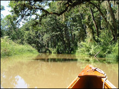
turbid waters of Coyote Creek are scenic and are an ideal place for
novice canoeists to paddle without having to face the winds from nearby
Fern Ridge Reservoir.
Flatwaters
at Fern Ridge
Coyote Creek is canoe country
By Allen Throop Venture contributor
VENETA
— After our usual Sunday breakfast pancakes, my two favorite women and
I started discussing what we should do during the sunny afternoon.
"Let's go canoeing," suggested Janet, my wife.
"Yes, an easy flat-water trip to somewhere different," added Heather, my daughter.
Without much thought, I said, "Let's try a slough on the south side of Fern Ridge Reservoir."
As soon as both women agreed, I started offering caveats.
I had never canoed in the area.
I had never talked to anyone who had canoed in the area.
I had never read anything about canoeing in the area.
Still,
from numerous drives between Eugene and Veneta, I knew that when the
reservoir is full, a large marsh exists on either side of the highway.
The chance of finding a canoe-able stream seemed high.
As we placed the canoe onto the roof rack, I continued to try to keep the expectations of my companions low.
If we didn't find a great spot, my paddle partners would be sure to bring this up many times in the future.
From
Eugene, we headed west on Oregon Highway 126. The highway and a
railroad track cross the south end of Fern Ridge reservoir on parallel
embankments.
The high steel framework of two railroad bridges
was easy to spot. Less obvious concrete highway bridges were adjacent
to the railroad bridges.
We assumed the bridges indicated stream
channels and elected to start at the easternmost bridge pair simply
because parking was better there.
Our arbitrary choice turned out to be the correct one.
After launching the canoe on the north side of the road, we paddled toward the bridges.
A
sign prohibiting motorboats from going under the bridge was the first
clue that a good canoe route awaited us. Since the bottoms of the
bridges were no more than four feet above the summer water level of the
lake, no sailboats would be heading our way.
Ropes hanging from bridge girders suggested that the bridge is a popular swimming hole.
As
ducking under the bridge, we entered a new world, the traffic noise
fading as we paddled easily up a meandering stream with Oregon ash and
big-leaf maples above steep banks.
About the only sounds we heard were birds and a mother and her young child enjoying a walk on a nearby path.
We saw no other canoeists until we were almost back to our starting point.
Coyote Creek, as we later found it was called, is perhaps the nicest still-water stream in the southern Willamette Valley.
Lake
canoeing can be fun, but from the middle of the lake the shore seems to
stand still, and wind can make paddling difficult. With no wind or
current, we could paddle when we wanted and drift when unusual
vegetation or a sudden sound along either shore caught our interest.
Coyote Creek would be a great place to practice canoeing skills without the worry of getting swept against deadfalls.
In the next two miles, the stream narrowed from 200 feet to 25 feet, but the depth remained adequate for paddling.
After about a mile, we found a boat launch next to Cantrell Road that looked far more inviting than where we started.
The
tributaries of many lakes are filled with sediments, making them
unsuitable for boating, but Coyote Creek is not clogged with sediment
thanks to the way the water levels are maintained for flood control.
The
water level is lowered dramatically during the winter to allow
collection of runoff water after heavy storms, turning Coyote Creek
into a small rushing stream unsuitable for canoeing. Sediment rushes
through, suspended in the fast-flowing stream, and is deposited in a
delta formed at the edge of the winter water level of the reservoir.
After returning home, I did some research on the area, which I should have done earlier.
The
land between Highway 126 and Cantrell Road is part of the Oregon
Department of Fish and Wildlife's Fern Ridge Wildlife Area. ODFW
maintains the boat ramp on Cantrell Road. South of Cantrell Road, the
land on either side of Coyote Creek is private but snags have been
removed from the stream to allow easy passage.
The primary
objective of the wildlife area is to provide habitat in winter for
waterfowl, shorebirds and other wildlife, with the canoe route as a
side benefit.
Throughout the early summer, the surface elevation
of the lake is maintained at about 374 feet above sea level. About the
middle of July, as water is released from the reservoir for irrigation
along the Long Tom River, the water level starts to drop slowly.
As
the level drops, the uppermost end of Coyote Creek may not be
canoe-able. On Oct. 1, the level is dropped quickly in preparation for
winter rains, eliminating the flat water needed for canoeing.
After
three hours of exploring Coyote Creek, we returned to the put-in spot,
where I struck up a conversation with a fisherman. His rambling story
that the reservoir would not be filled next year seemed hard to believe.
Unfortunately, the story is true.
During
the past year the U.S. Army Corps of Engineers, operators of the
reservoir, discovered depressions along the base of the dam. Drainage
pipes, installed when the dam was built, are collapsing.
While
they apparently do not represent an immediate safety threat, the Corps
intends to excavate the area next summer, evaluate the situation and
undertake the required repairs.
The full scope of the problem will not be known until the pipes are excavated and examined.
For
a cool afternoon on a quiet stretch of flooded river channel, pack up
your canoe and head for Coyote Creek — but don't wait too long.
For more information about Fern Ridge Wildlife Area contact:
To
reach the Cantrell Road canoe launch site, drive west on Highway 126 to
the intersection of for Maywood Recreation Site. Turn left at the
intersection, away from Maywood recreation site, and go south on
Central Road about three quarters of a mile. Turn left again on to
Cantrell Road. The launch site is about 1 1/4 mile on the left.